- Address: Off Sunyani-Fiapre Road, Ghana
Our Power, Our Planet: The Geospatial Story of Accra’s Green Future
By Dr. Ebenezer K. Siabi, Research Fellow, EORIC-UENR
It begins with a satellite’s silent sweep over West Africa — a watchful eye in the sky capturing the transformation of landscapes once teeming with green. What it sees is startling, but not surprising.
The urban horizon has shifted in Ghana’s bustling Greater Accra Region (GAR). What was once rangeland is now concrete. What was once the quiet rhythm of nature is now the pulse of sprawling city life. And in the quiet data streams pouring in from orbit, a story unfolds — not of doom, but of decisions.
This Earth Day 2025, as the world reflects on the theme “Our Power, Our Planet,” we turn to science not just for warnings but for wisdom. That’s where our journey begins—not just in space but in the lab, code, and the maps. This is the story of how geospatial research is helping us forecast the future of urbanisation—and possibly rewrite it.
A Battle on the Ground, Tracked from Space
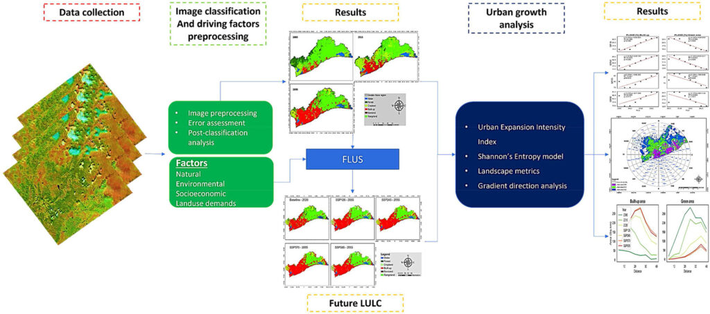
For over 15 years, researchers have collected satellite imagery and land cover data for Greater Accra. The goal was simple, but the task monumental: to understand how land use is changing and model what the future could look like depending on our choices today.
The study mapped possible futures using the Future Land Use Simulation (FLUS) model and various Shared Socioeconomic Pathways (SSPs). Tools like the Urban Expansion Intensity Index (UEII) and Shannon Entropy were used to measure the nature and intensity of sprawl. At the same time, landscape metrics revealed how green and built-up areas are evolving.
The results were revealing.
📘 Read the full study published in the Journal of Environmental Management: here
Futures Forged by Policy and People
In the most likely development scenarios — SSP245 (a middle-of-the-road path) and SSP370 (a world of regional rivalry) — urban expansion in Accra accelerates sharply. Built-up areas could grow by a staggering 87%, while green spaces may shrink by up to 12%. The loss is greatest near the Central Business District — a red flag for planners, environmentalists, and citizens alike.
But there’s an alternative.
Under SSP126 — a sustainability-focused scenario — the expansion is slower, more measured. Green spaces shrink less, and the patterns of growth are more deliberate. This version of the future isn’t just desirable — it’s possible.
Why This Matters — Especially Today
Earth Day is not just about reflection; it’s about responsibility. This research shows that our urban environments are not merely evolving—they are being shaped, actively and continuously, by the policies we pass, the plans we implement, and the power we choose to harness.
Without timely intervention, the unchecked loss of green spaces could trigger cascading effects on biodiversity, climate resilience, and public health. But the tools to change course are within reach.
One example is Ghana’s 2016 Land Use and Spatial Planning Act (Act 925). Investing in green infrastructure is another. Empowering city planners with data-driven foresight is the game-changer.
This is more than a study. It is a call to action. A reminder that even as cities rise, nature doesn’t have to fall.
The Path Forward: Greener Cities, Smarter Choices
Urban sprawl is not destiny. It is a design. And every design can be improved.
From satellite imagery to spatial simulation, geospatial researchers’ work is a quiet revolution in how we plan our cities—not just for efficiency but also for equity, ecology, and future generations.
As we celebrate Earth Day 2025, let us remember: our power lies not just in what we know, but in how we use it. For Accra, for West Africa, and every city standing on the edge of tomorrow, the message is clear:
Let’s push the #GreenCity agenda, plan purposefully, and protect our planet—starting with our neighbourhoods.